ELTRES(Sony’s LPWA) communication trial
Kenji Arashima
Sony Semiconductor Solutions Corporation
Sony has developed new Low Power Wide Area (LPWA) wireless network technology which is called ELTRES. This technology using Sub-GHz wireless with EIRP 20mW output can communicate long distance more than 100km line of sight and high speed movement more than 100km/h. ELTRES technology goes public with ETSI (European Telecommunications Standards Institute) as international standard.
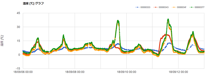
In this communication trial on Mt. Fuji, ELTRES tracker sent temperature data by 920 MHz EIRP 20 mW wireless from near window in the weather station on Mt. Fuji to trial gateway stations one of which is 100 km distance in Tokyo. It has success to receive data every 3 minutes for more than 1 month stability. It could get real time temperature data of the unmanned weather station after finished summer observation.
It could provide low power long distance wireless communication technology for support environmental research on Mt. Fuji which is no grid power and limited mobile network during winter season. Also we will study weather influence on constant wireless communication for 1 year until next summer.
In this another trial, climbers and a bulldozer has ELTRES tracker for location tracking during climbing up and down. It has success to receive GPS position, height, temperature, and acceleration data every 3 minutes from wide area in Mt Fuji. It could provide more safety for observation and climbing.
We are going to provide low power wide area network for Internet of Things with several field trials in Mt. Fuji.